


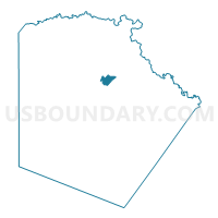
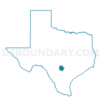
Voting District 3150, Bexar County, Texas
About
Outline

Summary
| Unique Area Identifier | 670880 |
| Name | Voting District 3150 |
| County | Bexar County |
| State | Texas |
| Area (square miles) | 4.15 |
| Land Area (square miles) | 4.15 |
| Water Area (square miles) | 0.00 |
| % of Land Area | 100.00 |
| % of Water Area | 0.00 |
| Latitude of the Internal Point | 29.53609220 |
| Longtitude of the Internal Point | -98.47002880 |
Maps

Graphs
Select a template below for downloading or customizing gragh for Voting District 3150, Bexar County, Texas


Neighbors
Neighoring Voting District (by Name) Neighboring Voting District on the Map
- Voting District 2109, Bexar County, TX
- Voting District 2116, Bexar County, TX
- Voting District 2129, Bexar County, TX
- Voting District 2132, Bexar County, TX
- Voting District 3060, Bexar County, TX
- Voting District 3061, Bexar County, TX
- Voting District 3062, Bexar County, TX
- Voting District 3063, Bexar County, TX
- Voting District 3064, Bexar County, TX
- Voting District 3065, Bexar County, TX
- Voting District 3080, Bexar County, TX
- Voting District 3081, Bexar County, TX
- Voting District 3082, Bexar County, TX
- Voting District 3120, Bexar County, TX
- Voting District 3145, Bexar County, TX
Top 10 Neighboring County Subdivision (by Population) Neighboring County Subdivision on the Map
- San Antonio Central CCD, Bexar County, TX (672,648)
- San Antonio North CCD, Bexar County, TX (309,717)
- San Antonio Northeast CCD, Bexar County, TX (233,237)
Top 10 Neighboring Place (by Population) Neighboring Place on the Map
Top 10 Neighboring Unified School District (by Population) Neighboring Unified School District on the Map
- North East Independent School District, TX (396,578)
- Alamo Heights Independent School District, TX (28,854)
Top 10 Neighboring State Legislative District Lower Chamber (by Population) Neighboring State Legislative District Lower Chamber on the Map
- State House District 122, TX (246,846)
- State House District 121, TX (158,873)
- State House District 123, TX (132,442)
Top 10 Neighboring State Legislative District Upper Chamber (by Population) Neighboring State Legislative District Upper Chamber on the Map
Top 10 Neighboring 111th Congressional District (by Population) Neighboring 111th Congressional District on the Map
Top 10 Neighboring Census Tract (by Population) Neighboring Census Tract on the Map
- Census Tract 1211.08, Bexar County, TX (7,109)
- Census Tract 1210, Bexar County, TX (7,095)
- Census Tract 1211.19, Bexar County, TX (5,362)
- Census Tract 1207.01, Bexar County, TX (5,326)
- Census Tract 1211.20, Bexar County, TX (5,103)
- Census Tract 1923, Bexar County, TX (4,448)
- Census Tract 1909.02, Bexar County, TX (3,783)
- Census Tract 1912.01, Bexar County, TX (3,143)
- Census Tract 1913.04, Bexar County, TX (3,054)
- Census Tract 1913.03, Bexar County, TX (1,561)